
 By zynmag
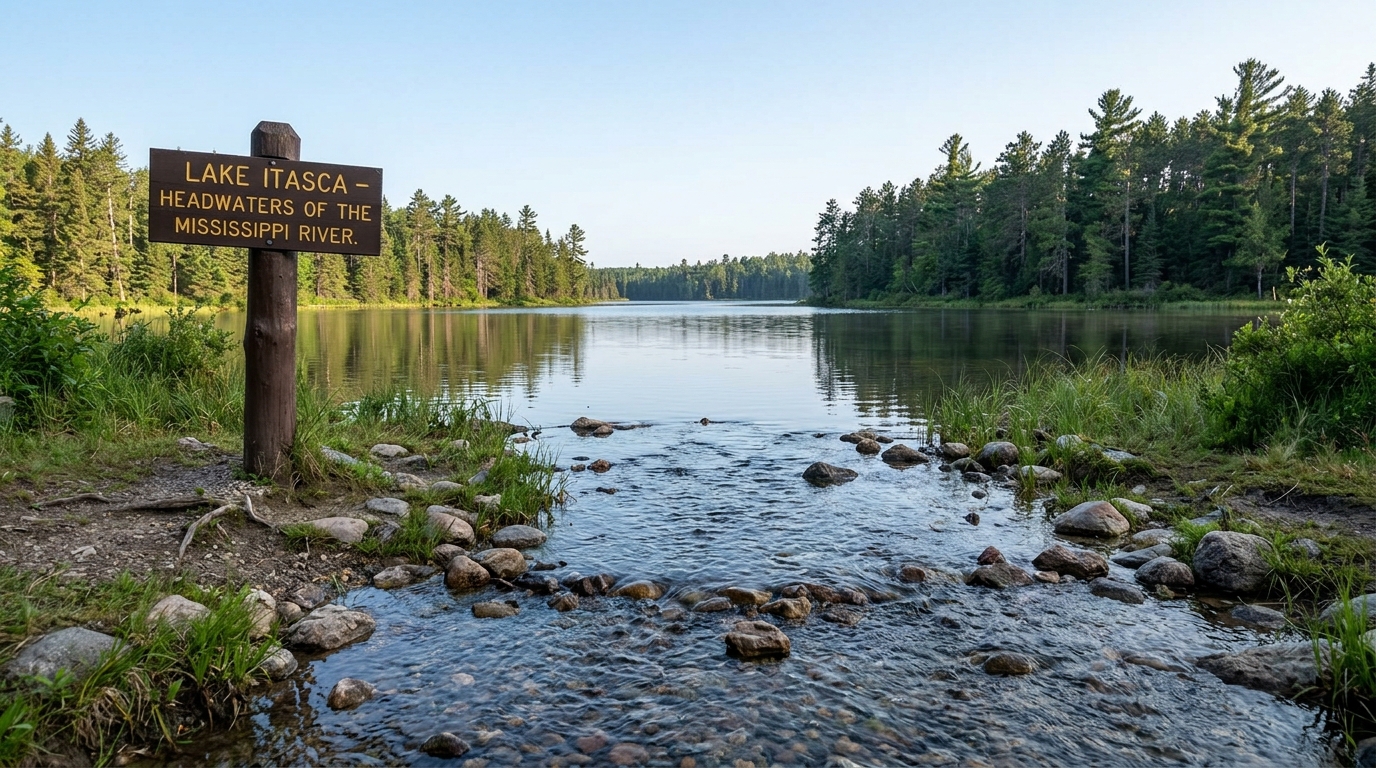
Reka Mississippi begins its extraordinary path at Lake Itasca in Minnesota and travels over 2,300 miles before reaching the Gulf of Mexico. This legendary waterway shapes American history, culture, and geography in ways few other rivers can match. Consequently, understanding its route from source to sea reveals stories of exploration, commerce, and natural wonder. Additionally, the river touches ten states and countless communities that rely on its waters daily. Throughout this piece, we will trace the river’s course, explore its cultural weight, and examine present-day challenges.
The Quiet Beginning at Lake Itasca
Visitors often feel surprised when they first see the source at Lake Itasca State Park. Indeed, the river starts as a narrow stream that people can cross by stepping on strategically placed rocks. Meanwhile, this modest beginning contrasts sharply with the massive waterway it eventually becomes downstream. Native tribes recognized this location’s importance long before European explorers ever arrived here. Subsequently, Henry Schoolcraft identified Lake Itasca as the true source in 1832, ending years of confusion. The lake sits roughly 1,475 feet above sea level, giving the water considerable elevation to descend. As a result, this starting point offers travelers a rare chance to witness a river’s infancy firsthand.
Flowing Through Minnesota’s Northern Wilderness
After leaving the lake, the young river winds through pristine forests and wetlands across northern Minnesota’s landscape. Similarly, it passes through several smaller lakes before gaining enough volume to resemble a true river. The surrounding terrain features dense pine forests, abundant wildlife, and clear waters that attract nature lovers. Moreover, this stretch demonstrates the river’s gradual transformation from a trickling stream into something substantial. Local ecosystems thrive along these upper reaches, supporting diverse fish, birds, and mammal populations year-round. Therefore, conservation groups consider this fragile northern environment a genuine priority worth protecting. The river continues building momentum as small tributaries join its flow throughout this stretch.
Growing Stronger Through the Upper Midwest
As the waterway continues southward, it passes directly through Minneapolis and Saint Paul in Minnesota. Consequently, urban development begins shaping the river’s character once it enters these populated areas. The Twin Cities region shows how communities built their identity around this vital natural resource. Furthermore, Saint Anthony Falls, located in Minneapolis, remains the only natural waterfall along the river’s entire length. Historically, this waterfall powered early industrial growth, drawing mills and factories to the region. Nevertheless, engineers eventually stabilized the falls to prevent erosion and protect the growing city nearby. The river then flows into Wisconsin and Iowa, forming natural boundaries between neighboring states.
Crossing the American Heartland
The river serves as a crucial dividing line between Iowa, Illinois, and Missouri as it moves south. Additionally, this section features numerous locks and dams that support heavy commercial navigation along the waterway. These engineering achievements allow barges to move grain, coal, and other essential goods efficiently. Meanwhile, small towns line the banks, each maintaining a unique bond with the water sustaining local economies. Agricultural communities particularly depend on the river for irrigation and transporting farm products to distant markets. Consequently, this waterway becomes an economic lifeline for much of the Midwest region. Bridges spanning the river at strategic points facilitate both commerce and everyday travel between communities.
St. Louis and the Meeting of Two Rivers
When the river reaches St. Louis, Missouri, it meets the Missouri River, dramatically increasing its total volume. Subsequently, this confluence marks a significant transformation in the character and power of the water downstream. The Gateway Arch stands nearby, symbolizing the city’s historic role as a launching point westward. Furthermore, this merger doubles the river’s sediment load, giving it the muddy brown color travelers often notice. Barge traffic intensifies below this point, reflecting the river’s growing importance for national trade routes. Meanwhile, historic riverfront neighborhoods showcase centuries of commerce, immigration, and cultural exchange along these busy banks. Therefore, St. Louis represents a genuine turning point in the river’s long journey southward.
The Lower River and the Mississippi Delta
South of Memphis, the waterway enters its lower stretch, characterized by wide meanders and rich floodplains. Additionally, this region includes some of the most fertile agricultural land found anywhere in North America. Cotton, soybeans, and rice thrive in the delta’s nutrient-rich soil deposited by centuries of flooding. Moreover, this area holds deep cultural significance, serving as the birthplace of blues music and distinct regional traditions. Levees line much of this stretch, built to control flooding and protect nearby farmland and towns. Nevertheless, catastrophic floods have occurred throughout history, including the devastating 1927 flood that reshaped federal flood policy. Consequently, engineers continue managing this delicate balance between agricultural productivity and flood control infrastructure.
New Orleans and the Approach to the Gulf
As the river nears its final destination, it passes through New Orleans, one of America’s most culturally distinctive cities. Furthermore, this stretch showcases the river’s economic importance through massive ports handling international shipping and trade. The city’s unique blend of French, Spanish, African, and American influences reflects centuries of river-based commerce. Meanwhile, the river here sits below sea level in places, protected by an extensive system of levees. Therefore, hurricane preparedness and flood management remain constant priorities for residents living near these lower banks. The Mississippi River Delta finally releases its waters into the Gulf of Mexico after this long journey. Consequently, this final stretch demonstrates how human engineering has reshaped a naturally wild waterway significantly.
The Ecological Significance of the River System
Beyond its role in commerce and culture, the river supports an extraordinarily diverse ecosystem throughout its length. Additionally, wetlands along the river provide critical habitat for migratory birds traveling the Mississippi Flyway annually. Fish populations, including catfish, sturgeon, and paddlefish, depend on the river’s varied water conditions for survival. Moreover, the river’s watershed drains water from 31 states, making it one of the largest river systems worldwide. This vast drainage area means agricultural runoff, pollution, and development decisions far upstream affect water quality downstream significantly. Consequently, environmental organizations continue advocating for better watershed management to protect this shared natural resource. Wetland restoration projects along the lower river aim to rebuild natural flood buffers lost to development.
Historical and Cultural Importance
Throughout American history, the river has served as a defining geographic and cultural landmark for the nation. Furthermore, Mark Twain’s writings, particularly “The Adventures of Huckleberry Finn,” cemented the river’s place in American literature permanently. Steamboats once dominated the waterway, carrying passengers and goods between river towns during the nineteenth century. Meanwhile, the river also played a significant role during the Civil War, particularly during the Vicksburg campaign. Native American communities lived along its banks for thousands of years before European settlement began. Additionally, the river’s name derives from the Ojibwe word “misi-ziibi,” meaning great river or gathering of waters. Therefore, understanding the river means understanding centuries of American expansion, conflict, and cultural development simultaneously.
Modern Challenges Facing the River
Today, the river faces significant environmental and infrastructure challenges that demand ongoing attention and investment. Additionally, agricultural runoff carrying fertilizers contributes to a large dead zone in the Gulf of Mexico. This hypoxic zone forms annually when nutrient pollution triggers algae blooms that deplete oxygen levels. Moreover, aging infrastructure, including locks and dams built decades ago, requires substantial modernization to remain functional. Climate change also threatens the river system through altered precipitation patterns and increased flooding frequency. Consequently, scientists and policymakers continue debating the best approaches to managing these interconnected environmental pressures effectively. Meanwhile, communities along the river advocate for infrastructure investment that balances economic needs with ecological protection.
Economic Impact Across the Nation
The river remains one of America’s most important commercial arteries, supporting industries across multiple states. Furthermore, barge transportation along this waterway moves billions of dollars in goods annually, including grain and petroleum products. This transportation method proves significantly more fuel-efficient than trucking or rail for bulk commodities over long distances. Additionally, port cities along the river, including Memphis, St. Louis, and New Orleans, depend heavily on river commerce. Agricultural exports particularly rely on this waterway to reach international markets efficiently through Gulf Coast ports. Therefore, any disruption to river navigation carries significant economic consequences for farmers and manufacturers nationwide. Recent droughts affecting water levels have highlighted the river’s vulnerability to changing weather patterns.
Recreation and Tourism Along the Waterway
Beyond commerce, the river offers extensive recreational opportunities for millions of visitors throughout the year. Additionally, fishing enthusiasts travel from across the country to experience the river’s diverse and abundant fish populations. Riverboat cruises allow tourists to experience sections of the waterway while learning about its rich history. Meanwhile, numerous state parks and wildlife refuges along the river provide hiking, birdwatching, and camping opportunities. The Great River Road, a scenic byway following the river’s course, attracts road trip travelers annually. Furthermore, cities along the river have invested in riverfront development, creating parks and attractions for residents and visitors. Consequently, the river continues drawing tourism dollars while preserving public access to this national treasure.
Conclusion: A River That Defines a Nation
From its humble beginning at Lake Itasca to its powerful conclusion at the Gulf of Mexico, this river tells America’s story. Throughout its 2,300-mile journey, it shapes landscapes, supports economies, and connects diverse communities across ten states. Additionally, the river’s ecological importance extends far beyond its banks, influencing wildlife and water quality across a massive watershed. Its cultural significance, immortalized in literature and music, reflects centuries of human interaction with this powerful natural force. Moreover, ongoing challenges around pollution, infrastructure, and climate change demand continued attention from policymakers and communities alike. Therefore, protecting this remarkable waterway ensures future generations can experience its beauty and economic importance. Ultimately, the journey from source to sea demonstrates nature’s power and humanity’s enduring relationship with water.